Generally, you start the crossing at the Mangatepopo car park and walk one way to the Ketetahi car park. As it is a one way track, you need to organize for transport from the Ketetahi car park. There are a number of shuttle services that provide transport or, if you happen to have two cars, you can leave one at each car park. We originally did the full crossing a few years ago and used a shuttle service from our hotel. This time, we just decided to leave our rental car at the Mangatepopo car park, hike up to the Red Crater and then head back the way we came to pick up our car. It ended up being about a 16 km walk for us, a little short of the full crossing, but my legs still hurt the next day, especially as we climbed to the highest point.
You need to be prepared to do the crossing. It is classifed as a "tramping track" which means that it is challenging, parts may be unformed, rough or steep and, for goodness sake, don't wear flip-flops/jandals. There isn't any water or food available along the way and you need to have a whole range of clothing as you never know what the weather will bring. You always see a few people that just don't quite realize what they've gotten themselves into. They probably should have looked at the Department of Conservation's website here and maybe done some research before they set out.
 |
| This is a map of the crossing. If you are a middle-aged lady like me, checking out where the toilets are is a pretty important part of the planning process. Source: Department of Conservation |
 |
| The crossing starts at 1120 meters and then climbs to 1886 meters at the Red Crater before descending to 760 meters at the Ketetahi carpark. I seemed to have forgotten how much of a climb it was the first time we did it. I'm not sure that if I had remembered what was involved if I would have done it again. Of course, now that I have climbed up to the Red Crater for the second time, I am glad I did it. But that's always the way it is - you curse and moan while you're doing crazy things, but happy that you met the challenge in the end. Source: Department of Conservation |
 |
| As you leave the Mangatepopo carpark, this is one of the first signs you run across. It warns you that you are about to enter an area with volcanic risks and that you should turn back at the Red Crater if you aren't comfortable with this. This was new for us. Last time we did the crossing, we didn't have to worry about this sort of thing, but in 2012 Mount Tongariro erupted twice. Fortunately, no one was injured, but there was damage done to the Department of Conservation's Ketetahi Hut. |
 |
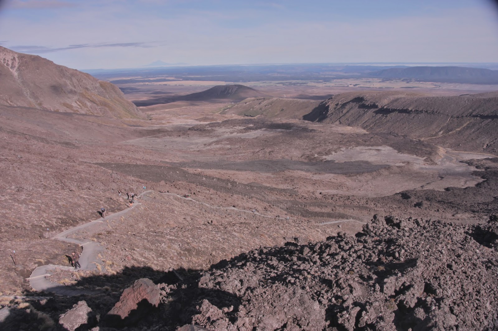
| After you set off from the carpark, you walk through the Mangatepopo Valley where you can see lava fields. You walk along a stream which looks really toxic to me with its garish orange and green coloring from the minerals. They warn you not to drink from it, but really who would drink from a toxic looking stream? The track is well formed at this point, with the handy boardwalks along the way to protect the fragile environment from our harsh little human feet. I was feeling good and relaxed, foolishly thinking that this was much easier than I had remembered. |
 |
| As you're walking along, you can see Mount Doom. The last time we did the crossing, we stopped so that Scott could climb up it. He wasn't able to go all the way up because he knew I was worrying down below about not having enough time for this side trip and that we would miss our shuttle bus at the other end. I am a bit of a worrywart that way. There was no way I was going to go up something called Mount Doom myself. And from the way he described climbing up the scree (for every 1 step forward, you slide backwards 3/4 of a step), it didn't sound like much fun. You also have to worry about some idiots above you pushing rocks down onto your head. I can think of better ways to spend my time. |
 |
| First toilet break - the Soda Springs loos. I was freezing by this point and put on my fleece. Lava fields are pretty desolate looking. Add in a few outhouses and you have a real scenic view. While you're there, you can take a quick side trip up to the Soda Springs. We skipped it this time. Instead, I used our little break to have a snack because the climb was about to start. From Soda Springs to the South Crater, you climb 340 meters on a track with some stairs. A lot of stairs. I'm the old lady who stops every two minutes to catch my breath. Fortunately, there seemed to be a lot of other old and young folks who needed frequent breaks that day. It is good not to feel alone. |
 |
| Right before you start your climb up to the South Carter, you see this sign urging you to consider turning back if the weather is poor, if you don't have the right equipment and clothes and if you aren't fit enough. We carried on. |
 |
| This is what the climb to South Crater looks like. A lot of blue poles showing you the way, some stairs and a lot of lava to walk across. |
 |
| And here is a view back down to Soda Springs to remind myself of why my legs hurt the next day. Along the way, Scott kept reassuring people that this was the worst part of the trek. We felt very superior and smug in the fact that we had done the crossing before and were in a position to cheer people on and tell them it really is worth it. |
 |
| And another Mount Doom shot. This time from the South Crater. Although, I think they wish we would stop calling it Mount Doom and start calling it by its proper name - Mount Ngauruhoe. |
 | ||
| Walking through the South Crater was such a relief. Relatively flat terrain - yeah! And it seems to be covered with these tribble-like plants. If you don't know what a tribble is, congratulations, you aren't a geek. |
 |
| It was starting to close in and the clouds were making everything look very spooky and alien in the South Crater. Apparently, South Crater isn't a crater, although it looked like one to me. Next stop the climb up the ridge to Red Crater. Enjoy the flatness while you can. |
 |
| Oh good, we're climbing again. In this particular section, they have ropes along the way to help you up and keep you from tumbling down into the South Crater. Handy. |
 |
| After the section with the ropes, this is what you end up walking across. You can just make out some people heading up the ridge in the background. It was really starting to close in quite a bit at this point and Scott was worried he wouldn't get any good shots of the Red Crater and the lakes. But not to worry, the clouds cleared. We have some for you. That is if you're actually still reading this post. There have a been a lot of pictures so far. It is kind of like when you go to someone's house and they just have to show you all of their travel photos and you can barely contain your boredom and you shout, "Quick, look out the window! The aliens have landed!" While they're distracted, you chuck their photo album under the sofa and pretend you don't know what happened to it. Anything to stop having to look at those photos of the Tongariro Crossing. |
 |
| Oh good, you're still here. I give you Red Crater. |
 |
| And as a bonus because you are such a dedicated and faithful reader, one more picture up close of Red Crater. You can smell the sulfur all around you up here - a sure sign that things are still active. And there are areas where you can feel the geo-thermal warmth coming up out of the ground, which is helpful because it was really windy and cold up top. |
 |
| One of the main draw cards of the crossing are the lakes. This is a view of the Emerald Lakes. The picture really doesn't do justice to their color. As the name says, they are an amazing emerald shade caused by the minerals seeping into them. |
 |
| This is a view of the Blue Lake. It is sacred (or tapu), so don't swim or eat food around it. If you're continuing along the crossing, you skirt along Blue Lake and then head down into the forest for the descent to the Ketetahi carpark. This time, we turned back at Red Crater and made our way back to the start. The final part of the crossing is worthwhile, but the trek through the forest isn't nearly as amazing as the first half of the crossing in our opinion. Whichever way you do it, it is well worth doing. |
Linked up with Bonnie, Kaelene, Sammy & Van for Travel Tuesday.
Oh my gosh! I totally want to go there and I fear that all the signs warning me of my impending doom should I choose to go forward would only spur me on, and probably not in a good way. No way am I 'fit enough' to do that kind of trek, and yet, I would probably do it and then both regret it and be glad of it later. Also, I DO know what a tribble is. I suppose that means I'm a geek of some kind. Or I'm old enough to remember that episode. But having raised a son on the Hobbit trilogy, starting when he was three and began watching the cartoon versions, I must see Mount Doom. I can still remember his little voice, singing the song from the cartoon: "The Cracks of Doom.... the Jeepers of Fire. " Hey, I'm not making that up. That's what he would sing. Red crater is awesome. Maybe I could just get a helicopter to take me up there and bring me back.
ReplyDeleteIt really is worth it - I'm not very fit and if I can do it, anyone can. Even a tribble. Although I'm not sure how as they don't seem to have feet. I wonder if tribbles would make good boat pets? So cute that your son sang a Mount Doom song!
DeleteThis reminds me so much of hiking in Iceland, you see those signs everywhere since hot water is all over the place. That red crater is beautiful!
ReplyDeleteI would love to be able to add Iceland to my list of places I've hiked in - some day hopefully!
DeleteI'm planing to visit New Zealand next Jan/Feb and this is definitely going on my to-do list now :)
ReplyDeleteA great addition to the to do list! Have a fabulous time on your trip to NZ!
DeleteThose views are pretty amazing, but I'm not sure that hike is for me.
ReplyDeleteIf only there was a helicopter which could take you up top so you could enjoy the views without having to make the climb. I bet it would be a pretty popular option with people :-)
DeleteAmazing emerald water!
ReplyDeleteThey Emerald Lakes are amazing - the photos really don't do justice at all to their actual colour.
DeleteBeautiful pictures! I'm just afraid I would collapse along the way - really need to improve my stamina! I've seen some volcanoes on the Canary Islands in Spain but they weren't active so I haven't seen any lava so far. But at least I got myself some volcano stones ;)
ReplyDeleteI stopped a lot on the way up. I am not very fit and needed a lot of breaks. But lots of other folks seemed to be doing the same so I didn't feel so bad. We hiked up Mt Teide in Tenerife - did you see that one? It was amazing!
DeleteLovely photo's. I did teh same walk a few years ago, only there was a lot of snow - it nearly killed me!
ReplyDeleteI cannot even begin to imagine doing the crossing in snow! Wow - that is impressive!
DeleteWhat beautiful pictures and what an amazing experience! Another thing to add to my New Zealand to do list for when I head back. The Emerald Lakes really are spectacular too.
ReplyDeleteI'm so glad we did it - you'll love it too!
DeleteMy husband always says it's his dream to visit New Zealand. I called him over to read this post and see the pictures and I think it only strengthened his resolve! This is precisely his type of hike...maybe we will get over there someday.
ReplyDeleteNew Zealand seems to be on a lot of people's dream destinations. I feel lucky that I got to move here for work and experience it all!
DeleteWoah! Red Crater looks amazing! I'd love to see that in person.
ReplyDeleteIt is soooo much better in person - the photos don't really do it justice.
DeleteWell, from one little old lady to another, congratulations on making it (twice!) and thanks for all the warnings. (I think! :( ) I was starting to have serious doubts over the lava field. If there's a crack or loose rock where I can wedge my foot stuck I always do! But then you showed me Red Crater and I was sold :) Thanks so much for sharing this. I'm half glad I'm so far away and don't have to take up the challenge.
ReplyDeleteIf I can do the crossing - anyone can! I'm not the most sporty person in the world, but the views and sights on the crossing are so worth any pain you may feel :-)
Delete